My previous post about BP lowballing the Gulf Oil spill leak has some weight to it. CNN reported that the leak is up to 70k barrels a day based on video of the leaking pipe. That is 2,940,000 gallons DAILY flowing into the gulf !
In the 3 weeks since the disaster, 61,740,000 gallon of oil into the Gulf of Mexico.
(CNN) -- A U.S. congressman said he will launch a formal inquiry Friday into how much oil is gushing into the Gulf of Mexico after learning of independent estimates that are significantly higher than the amount BP officials have provided.
Rep. Edward Markey, a Democrat from Massachusetts, said he will send a letter to BP and ask for more details from federal agencies about the methods they are using to analyze the oil leak. Markey, who chairs a congressional subcommittee on energy and the environment, said miscalculating the spill's volume may be hampering efforts to stop it.
"I am concerned that an underestimation of the oil spill's flow may be impeding the ability to solve the leak and handle the management of the disaster," he said in a statement Thursday. "If you don't understand the scope of the problem, the capacity to find the answer is severely compromised."
BP officials have said 5,000 barrels per day of crude, or 210,000 gallons, have been leaking for the past three weeks.
But a researcher at Purdue University has predicted that about 70,000 barrels of oil per day are gushing into the Gulf after analyzing videos of the spill.
BP 'making it up as they go along'
Purdue University
Associate professor Steve Wereley said he arrived at that number after spending two hours Thursday analyzing video of a spill using a technique called particle image velocimetry. He said there is a 20 percent margin of error, which means between 56,000 and 84,000 barrels could be leaking daily.
"You can't say with precision, but you can see there's definitely more coming out of that pipe than people thought. It's definitely not 5,000 barrels a day," Wereley said.
He said he reached his estimate of 70,000 barrels per day by calculating how far and how fast oil particles were moving in the video.
Markey's statement said that officials from BP, Transocean and Halliburton estimated a worst-case-scenario maximum flow at 60,000 barrels a day during congressional testimony May 4.
More than 260,000 barrels of oil spilled during the 1989 wreck of the supertanker Exxon Valdez in Alaska's Prince William Sound.
BP spokesman Mark Proegler said that the company stands by its 5,000 barrels per day estimate. He said the company reached that number using data, satellite images and consultation with the Coast Guard and the National Oceanic and Atmospheric Administration. But there is no way to calculate a definite amount, he said.
"We are focused on stopping the leak and not measuring it," he said.
Oil has been gushing into the gulf since April, when an explosion sank the Deepwater Horizon drill rig. The blast left 11 workers lost at sea.
BP said Thursday that it would attempt to insert a new section of pipe into the riser of its damaged undersea well to capture the leaking oil.
A previous effort to cap the gusher with a four-story containment dome failed when natural gas crystals collected inside the structure, plugging an outlet at the top.
BP, the Coast Guard, and state and local authorities have scrambled to keep the oil from reaching shore or the ecologically delicate coastal wetlands off Louisiana. They have burned off patches of the slick, deployed more than 280 miles of protective booms, skimmed as much as 4 million gallons of oily water off the surface of the Gulf and pumped more than 400,000 gallons of chemical dispersants onto the oil.
Investigators are still trying to determine what caused the April 20 explosion aboard the Deepwater Horizon.
BP has blamed drilling contractor Transocean Ltd., which owned the rig. Transocean says BP was responsible for the wellhead's design and that oilfield services contractor Halliburton was responsible for cementing the well shut once drilled. And Halliburton says its workers were just following BP's orders, but that Transocean was responsible for maintaining the rig's blowout preventer.
Friday, May 14, 2010
Wednesday, May 12, 2010
Obama uses Connecticut Soc. Sec. #
Investigators: Obama uses Connecticut Soc. Sec. #
3 experts insist White House answer new questions about documentation
NEW YORK – Two private investigators working independently are asking why President Obama is using a Social Security number set aside for applicants in Connecticut while there is no record he ever had a mailing address in the state.
In addition, the records indicate the number was issued between 1977 and 1979, yet Obama's earliest employment reportedly was in 1975 at a Baskin-Robbins ice-cream shop in Oahu, Hawaii.
WND has copies of affidavits filed separately in a presidential eligibility lawsuit in the U.S. District Court of the District of Columbia by Ohio licensed private investigator Susan Daniels and Colorado private investigator John N. Sampson.
The investigators believe Obama needs to explain why he is using a Social Security number reserved for Connecticut applicants that was issued at a date later than he is known to have held employment.
The Social Security website confirms the first three numbers in his ID are reserved for applicants with Connecticut addresses, 040-049.
"Since 1973, Social Security numbers have been issued by our central office," the Social Security website explains. "The first three (3) digits of a person's social security number are determined by the ZIP code of the mailing address shown on the application for a social security number."
The question is being raised amid speculation about the president's history fueled by an extraordinary lack of public documentation. Along with his original birth certificate, Obama also has not released educational records, scholarly articles, passport documents, medical records, papers from his service in the Illinois state Senate, Illinois State Bar Association records, any baptism records and adoption papers.
Robert Siciliano, president and CEO of IDTheftSecurity.com and a nationally recognized expert on identity theft, agrees the Social Security number should be questioned.
"I know Social Security numbers have been issued to people in states where they don't live, but there's usually a good reason the person applied for a Social Security number in a different state," Siciliano told WND.
WND asked Siciliano whether he thought the question was one the White House should answer.
"Yes," he replied. "In the case of President Obama, I really don't know what the good reason would be that he has a Social Security number issued in Connecticut when we know he was a resident of Hawaii."
Siciliano is a frequent expert guest on identify theft on cable television networks, including CNN, CNBC and the Fox News Channel.
Daniels and Sampson each used a different database showing Obama is using a Social Security number beginning with 042.
WND has further confirmed that the Social Security number in question links to Obama in the online records maintained by the Selective Service System. Inserting the Social Security number, his birth date and his last name produces a valid Selective Service number.
To verify the number was issued by the Social Security Administration for applicants in Connecticut, Daniels used a Social Security number verification database. She found that the numbers immediately before and immediately after Obama's were issued to Connecticut applicants between the years 1977 and 1979.
"There is obviously a case of fraud going on here," Daniels maintained. "In 15 years of having a private investigator's license in Ohio, I've never seen the Social Security Administration make a mistake of issuing a Connecticut Social Security number to a person who lived in Hawaii. There is no family connection that would appear to explain the anomaly."
Does the Social Security Administration ever re-issue Social Security numbers?
"Never," Daniels said. "It's against the law for a person to have a re-issued or second Social Security number issued."
Daniels said she is "staking my reputation on a conclusion that Obama's use of this Social Security number is fraudulent."
There is no indication in the limited background documentation released by the Obama 2008 presidential campaign or by the White House to establish that Obama ever lived in Connecticut.
Nor is there any suggestion in Obama's autobiography, "Dreams from My Father," that he ever had a Connecticut address.
Also, nothing can be found in the public record that indicates Obama visited Connecticut during his high-school years.
Sampson's affidavit specifies that as a result of his formal training as an immigration officer and his 27-year career in professional law enforcement, "it is my knowledge and belief that Social Security numbers can only be applied for in the state in which the applicant habitually resides and has their official residence."
Daniels told WND she believes Obama had a different Social Security number when he worked as a teenager in Hawaii prior to 1977.
"I doubt this is President Obama's originally issued Social Security number," she told WND. "Obama has a work history in Hawaii before he left the islands to attend college at Occidental College in California, so he must have originally been issued a Social Security number in Hawaii."
The published record available about Obama indicates his first job as a teenager in Hawaii was at a Baskin-Robbins in the Makiki neighborhood on Oahu. USA Today reported the ice-cream shop still was in operation one year after Obama's inauguration.
Politifact.com, a website typically supportive of Obama, claims he worked at the Baskin-Robbins in 1975 or 1976, prior to the issuance of the number in question.
"It is a crime to use more than one Social Security number, and Barack Obama had to have a previous Social Security number to have worked at Baskin-Robbins," she insisted. "Under current law, a person is not permitted to use more than one Social Security number in a lifetime."
Another anomaly in the law enforcement databases searched by Daniels and Sampson is that the date 1890 shows up in the field indicating the birth of the number holder, along with Obama's birth date of 08/04/1961. A third date listed is 04/08/1961, which appears to be a transposition of Obama's birth date in an international format, with the day before the month.
Daniels disclosed to WND the name of the database she searched and produced a computer screen copy of the page that listed 1890 as a date associated with the 042 Social Security number.
Daniels said she can't be sure if the 1890 figure has any significance. But she said it appears the number Obama is using was previously issued by the Social Security Administration.
After an extensive check of the proprietary databases she uses as a licensed private investigator, Daniels determined that the first occurrence of Obama's association with the number was in 1986 in Chicago.
Daniels assumes, but cannot prove, that Obama took on a previously issued Social Security number that had gone dormant due to the death of the original holder.
Daniels has been a licensed private investigator in Ohio since 1995. Sampson formed his private investigations firm, CSI Consulting and Investigations, in 2008. He previously worked as a deportations law enforcement officer with the U.S. Department of Homeland Security.
The Daniels and Sampson affidavits were originally recorded by attorney Orly Taitz in an eligibility case against Obama last year.
Tuesday, May 11, 2010
BP Gulf Oil is actually leaking up to 480 million gallons daily !!
I did some research into oil pipe flow calculations and the answer is staggering !! BP wants us to beleive only 250,000 gallons a day are leaking, when in fact it is much much more then that. I followed the formula they use to calculate pipe flow and based on the figures, it is not good !!
www.pipeflowcalculations.com
UPDATE: Two individuals applied their own formulas to the data variables. Conclusion was the same. This is enough evidence to hold weight in court.
We are facing these figures as authentic oil flow.
Skeptical? Completely understood! Do the math yourself and you will see.
I will include all data and tools used to get to this conclusion.
Flow Calculator
[link to www.pipeflowcalculations.com]
Data
L = Length of pipe from seafloor to oil = 9,754 meters
D = Diameter of pipe = 914 mm to 215 mm
note - standard diameters for oil drilling, lowest value is used due to depth.
P1 = Pressure in oil reserve = 15,000 psi to 70,000 psi
P2 = Pressure at release point = 2,000 psi
P1-P2 = Pressure difference in transit = 13,000 to 68,000 psi
T = Temperature of oil in reserve = 633*K
note - 35,000 feet is averaged at 360*C
Q = Volumetric Flow Rate
G = Mass Flow Rate
rho = Density of oil = 924 kg/m3
The Calculators Results
70k PSI in Oil Reserve
Q = 352,259 m3/hr
G = 3.25487872E+008 kg/h = 325,487,872 kg/h = 116,301,122 gal/hr
15k PSI in Oil Reserve
Q = 64,210 m3/hr
G = 5.9330372E+007 kg/h = 59,330,372 kg/h = 21,199,527 gal/hr
Conclusion
21 to 116 million gallons per hour
This is mathematical fact and all variables are sound and factual. Please try to debunk this!
I hope I am wrong but I would like others to calculate themselves.
CALCULATION REPORT
1. volumetric flow rate (Q):
Q = 64210.363 m3/h
2. mass flow rate (G):
G = 5.9330372E+007 kg/h
3. lenght (L):
L = 9754 m
4. diameter (D):
D = 215 mm
5. density (rho):
rho = 924 kg/m3
6. tempearture (T):
T = 633 K
7. volumetric flow rate at the start (Q1):
Q1 = 145.78026 m3/h
8. volumetric flow rate at the end (Q2):
Q2 = 1093.3519 m3/h
9. pressure on the pipe start (p1):
p1 = 15000 psi
10. pressure on the pipe end (p2):
p2 = 2000.0 psi
11. pressure drop (p1-p2):
p1-p2 = 13000 psi
12. velocity at the start (V1):
V1 = 1.1153976 m/s
13. velocity at the end (V2):
V2 = 8.365481 m/s
It is now and has been pumping 1 mil gallons per day. The 200k gallon estimate is a very low ball number. If the well head fails it will pump 2.5 mil gallons per day.
There have been several links posted to articles by industry experts that say based on the satellite photos the 200k gallon estimate is way, way too low.
To put this in perspective, he Exxon Valdez spill in Prince William Sound of Alaska was 11mil. gallons of crude.
Monday, May 10, 2010
NASA Images of the Gulf Oil Slick
 NASA is keeping a very close eye on the Gulf BP Oil spill. Here are some very high res photo images they have taken from satellites and the International Space Station.
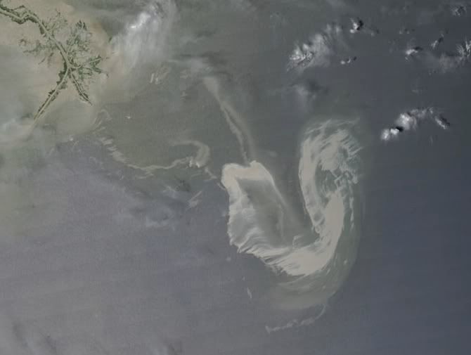
NASA's Terra satellite flew over the Deepwater Horizon rig's oil spill in the Gulf of Mexico on Saturday, May 1 and captured a natural-color image of the slick from space. The oil slick resulted from an accident at the Deepwater Horizon rig in the Gulf of Mexico.
The Moderate Resolution Imaging Spectroradiometer (MODIS) instrument on NASA’s Terra satellite captured a natural-color image. The oil slick appeared as a tangle of dull gray on the ocean surface, made visible to the satellite sensor by the sun’s reflection on the ocean surface. On May 1, most of the oil slick was southeast of the Mississippi Delta.
The National Oceanic and Atmospheric Administration (NOAA) is the lead agency on oil spills and uses airplane fly-over's to assess oil spill extent. NASA's Terra and Aqua satellites are also helping NOAA with satellite images of the area.
On Sunday, May 2, NOAA restricted fishing in federal waters of the Gulf of Mexico from the mouth of the Mississippi to Pensacola Bay for at least ten days. More details about the closure can be found at: http://sero.nmfs.noaa.gov.
In addition to the federal closure, Louisiana closed vulnerable fisheries in state waters -- within three miles of the coast. NOAA noted that anyone wanting to report oil on land, or for general Community and Volunteer Information, please call 1-866-448-5816. To report oiled or injured wildlife, please call 1-800-557-1401.

The Deepwater Horizon oil spill (appearing as a dull gray color) is southeast of the Mississippi Delta in this May 1, 2010, image from NASA's MODIS instrument. Credit: NASA/Goddard/MODIS Rapid Response Team

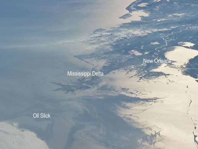
Japan Aerospace Exploration Agency (JAXA) astronaut Soichi Noguchi, Expedition 23 flight engineer, photographed the tail end of the Mississippi Delta showing the oil slick in the Gulf of Mexico on May 4, 2010. Part of the river delta and nearby Louisiana coast appear dark in the sunglint. This phenomenon is caused by sunlight reflecting off the water surface, in a mirror-like manner, directly back towards the astronaut observer onboard the International Space Station (ISS). The sunglint improves the identification of the oil spill which is creating a different water texture (and therefore a contrast) between the smooth and rougher water of the reflective ocean surface. Other features which cause a change in surface roughness that can be seen in sunglint are wind gusts, naturally occurring oils that will be gathered by and take the form of water currents or wave patterns, and less windy areas behind islands. Credit: NASA

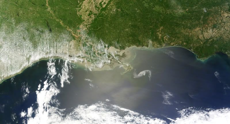
On April 29, the MODIS image on the Terra satellite captured a wide-view natural-color image of the oil slick (outlined in white) just off the Louisiana coast. The oil slick appears as dull gray interlocking comma shapes, one opaque and the other nearly transparent. Sunglint -- the mirror-like reflection of the sun off the water -- enhances the oil slick’s visibility. The northwestern tip of the oil slick almost touches the Mississippi Delta. Credit: NASA/Earth Observatory/Jesse Allen, using data provided courtesy of the University of Wisconsin’s Space Science and Engineering Center MODIS Direct Broadcast system.

NASA's Terra and Aqua satellites are helping the National Oceanic and Atmospheric Administration (NOAA) keep tabs on the extent of the recent Gulf oil spill with satellite images from time to time. NOAA is the lead agency on oil spills and uses airplane fly-overs to assess oil spill extent.
A semisubmersible drilling platform called the Deepwater Horizon located about 50 miles southeast of the Mississippi Delta experienced a fire and explosion at approximately 11 p.m. CDT on April 20. Subsequently, oil began spilling out into the Gulf of Mexico and efforts to contain the spill continue today. NASA's Terra and Aqua satellite imagery has captured the spill in between cloudy days.
NOAA used data from the Moderate Imaging Spectroradiometer or MODIS instrument from the Terra satellite on April 26, 27 and 29 to capture the extent of the oil spill, which measured 600-square-miles. The MODIS instrument flies aboard both the Terra and Aqua satellites.
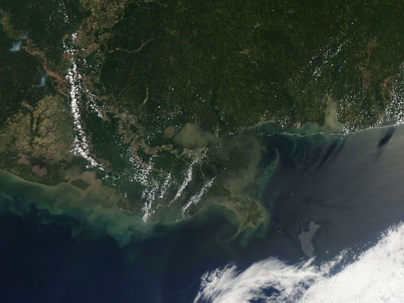
This satellite image from NASA's Terra satellite on April 27 at 12:05 CDT shows the outline and extent of the oil slick from the Deepwater Horizon drilling platform. The red dot represents the platform. The coasts of Mississippi and Alabama appear at the top of the image. Credit: NOAA/NASA
› Larger image In the satellite image from April 27 at 12:05 p.m. CDT the MODIS image showed that the oil slick was continuing to emanate from the spill location. Individual slicks lay just north of 29 degrees and zero minutes north, where they have been noted in the days before. Oil had spread further east and the edge of the slick passed 87 degrees and 30 minutes west compared to the MODIS image taken on April 26. The April 26 satellite image came from NASA's Aqua satellite.
On April 29, the MODIS image on the Terra satellite captured a natural-color image of the oil slick just off the Louisiana coast. The oil slick appeared as dull gray interlocking comma shapes, one opaque and the other nearly transparent. The northwestern tip of the oil slick almost touches the Mississippi Delta.
Deepwater Horizon had more than120 crew aboard and contained an estimated to 17,000 barrels of oil (700,000 gallons) of number two fuel oil or marine diesel fuel.
Today, April 30, NOAA declared the Deepwater Horizon incident "a Spill of National Significance (SONS)." A SONS is defined as, "a spill that, due to its severity, size, location, actual or potential impact on the public health and welfare or the environment, or the necessary response effort, is so complex that it requires extraordinary coordination of federal, state, local, and responsible party resources to contain and clean up the discharge" and allows greater federal involvement. NOAA's estimated release rate of oil spilling into the Gulf is estimated at 5,000 barrels (210,000 gallons) per day based on surface observations and reports of a newly discovered leak in the damaged piping on the sea floor.
NOAA reported on April 29 that dispersants are still being aggressively applied to the oil spill and over 100,000 gallons have been applied. NOAA's test burn late yesterday was successful and approximately 100 barrels of oil were burned in about 45 minutes. NOAA is flying planes over the area and using NASA satellite imagery from the Terra and Aqua satellites to monitor the spill.
Subscribe to:
Posts (Atom)


