Showing posts with label oil spill. Show all posts

Thursday, May 27, 2010

Gulf of Mexico oil spill called worst in U.S. history

There's no end in sight for the situation in the Gulf of Mexico. Anderson Cooper reports live tonight from the region as BP attempts to stop the leak. Watch "AC360°" tonight at 10 ET on CNN for the latest on stopping the leak.

Venice, Louisiana (CNN) -- The Gulf of Mexico undersea gusher has already spilled more oil than the Exxon Valdez disaster -- possibly more than twice as much, making it the largest oil spill in U.S. history -- government scientists said Thursday.

Scientists observed 130,000 to 270,000 barrels of oil on the water's surface on May 17, and think a similar amount had already been burned, skimmed, dispersed or evaporated.

That would mean 260,000 to 520,000 barrels had been leaked as of 10 days ago. The Exxon Valdez leaked about 250,000 barrels into Alaska's Prince William Sound in 1989.

The estimate came as an underwater tussle between oil and mud unfolded in BP's latest attempt to cap the runaway leak. But whether mud is able to defeat oil won't be known until later Thursday.


Federal authorities remained cautiously optimistic about the maneuver known as a top kill, which BP started Wednesday afternoon.


http://mfile.akamai.com/97892/live/reflector:45685.asx?bkup=49182

"The top kill procedure is going as planned, and it is moving along as everyone had hoped," said U.S. Coast Guard Adm. Thad Allen, who is leading the government's response to the oil spill.

A BP official said it was too early to draw any conclusions about the success of the effort.

"We appreciate the optimism, but the top kill operation is continuing through the day today -- that hasn't changed," the official said. "We don't anticipate being able to say anything definitive on that until later today."


Meanwhile, government scientists said Thursday that the undersea gusher was spewing oil at a rate of 12,000 to 19,000 barrels a day, more than twice the 5,000-barrel estimate given by BP.

The government had two different teams of scientists estimate the rate of flow using two different methods, U.S. Geological Survey Director Marcia McNutt said.

Also Thursday, sources said that Minerals Management Service Director Elizabeth Birnbaum has been fired.

A senior Obama administration official said an official announcement will be made during the president's news conference scheduled for Thursday afternoon.

The decision to fire Birnbaum comes after a recently released report highlighting what many observers have characterized as widespread corruption at the Minerals Management Service, which is part of the Interior Department.

A dramatic video feed from the ocean floor showed enormous brown plumes billowing at the well. BP Managing Director Bob Dudley described it as a "titanic arm wrestling match" between the gushing oil and the thousands of pounds of drilling mud -- a thick, viscous fluid -- being pumped in to stop the flow.

So far, "that operation is proceeding like we would expect it," Dudley said.

If the mud succeeds in pushing back the oil, BP plans to seal the well with cement.


That response is sure to generate more questions for President Obama, who has come under fire for not doing enough.

Obama fought back the criticism Thursday by announcing that he is delaying oil exploration off the coast of Alaska, canceling the sale of a lease to drill off Virginia and extending the moratorium on permits to drill any new deepwater wells for six months, a White House official said.

He has also launched a presidential commission's safety review of offshore drilling in response to the incident.

He was expected to discuss other recommendations that came from a 30-day review he ordered shortly after the April 20 explosion aboard the drilling rig Deepwater Horizon that triggered the leak and left 11 men missing and presumed dead.

"If it's successful, and there are no guarantees, it should greatly reduce or eliminate the flow of oil now streaming into the Gulf from the sea floor," Obama said after discussing the top kill procedure with Energy Secretary Steven Chu, who was in Houston, Texas, at the command center. "And if it's not, there are other approaches that may be viable."

But he didn't elaborate on what he meant by "other approaches."

No fewer than four congressional hearings were scheduled Thursday regarding the spill. The committees were set to hear from oil rig workers and their families. Lamar McKay, chairman and president of BP America, and Steven Newman, president and CEO of Transocean, owner of the oil rig that exploded and sank, were also expected to testify.

Democratic Rep. Jim Moran, head of a key House appropriations subcommittee, told Interior Secretary Ken Salazar he "will be responsible" for ensuring there isn't a repeat of the oil spill "catastrophe" in the Gulf of Mexico.

Salazar said he remains "very confident and resolute that we will solve the problem."


Early Thursday morning, the Unified Command in Louisiana said it recalled all 125 commercial vessels in Breton Sound, Louisiana, after four crew members in three vessels involved in the oil recovery operations reported feeling sick.

Medics were going boat to boat to evaluate crew members as a precaution, Lt. Cmdr. Rob Wyman said.

The four crew members, who prompted the recall, reported feeling nauseated and dizzy, and complained of headaches and chest pains, the Deepwater Horizon Incident Joint Information Center said.

The other crew members on those boats declined treatment at the dock.

"No other personnel are reporting symptoms, but we are taking this action as an extreme safeguard," Coast Guard Chief Petty Officer Robinson Cox said.

All four crew members were taken to West Jefferson Medical Center outside New Orleans. Hospital spokeswoman Taslin Alfonzo said that in addition to the four, the medical center also received three other men who were working on the spill cleanup.

The vessels were involved in cleaning up oil that has been gushing into the Gulf of Mexico since the oil rig sank about 40 miles south of Louisiana.


If BP's top kill procedure fails, an attempt would be made to contain more of the flow than is currently being siphoned through a riser insertion tool, according to Doug Suttles, the company's chief operating officer.

That would likely be followed by an attempt to place another blowout preventer on top of the existing one, which failed, he said.

"Everyone has experienced a great deal of frustration that we're 30-some odd days into this oil spill and we haven't yet contained the flow," Suttles said. But, he added, "We're doing everything we can to bring it to closure."

Monday, May 10, 2010

NASA Images of the Gulf Oil Slick

NASA is keeping a very close eye on the Gulf BP Oil spill. Here are some very high res photo images they have taken from satellites and the International Space Station.

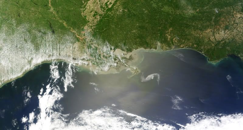
NASA's Terra satellite flew over the Deepwater Horizon rig's oil spill in the Gulf of Mexico on Saturday, May 1 and captured a natural-color image of the slick from space. The oil slick resulted from an accident at the Deepwater Horizon rig in the Gulf of Mexico.

The Moderate Resolution Imaging Spectroradiometer (MODIS) instrument on NASA’s Terra satellite captured a natural-color image. The oil slick appeared as a tangle of dull gray on the ocean surface, made visible to the satellite sensor by the sun’s reflection on the ocean surface. On May 1, most of the oil slick was southeast of the Mississippi Delta.

The National Oceanic and Atmospheric Administration (NOAA) is the lead agency on oil spills and uses airplane fly-over's to assess oil spill extent. NASA's Terra and Aqua satellites are also helping NOAA with satellite images of the area.

On Sunday, May 2, NOAA restricted fishing in federal waters of the Gulf of Mexico from the mouth of the Mississippi to Pensacola Bay for at least ten days. More details about the closure can be found at: http://sero.nmfs.noaa.gov.
In addition to the federal closure, Louisiana closed vulnerable fisheries in state waters -- within three miles of the coast. NOAA noted that anyone wanting to report oil on land, or for general Community and Volunteer Information, please call 1-866-448-5816. To report oiled or injured wildlife, please call 1-800-557-1401.


The Deepwater Horizon oil spill (appearing as a dull gray color) is southeast of the Mississippi Delta in this May 1, 2010, image from NASA's MODIS instrument. Credit: NASA/Goddard/MODIS Rapid Response Team


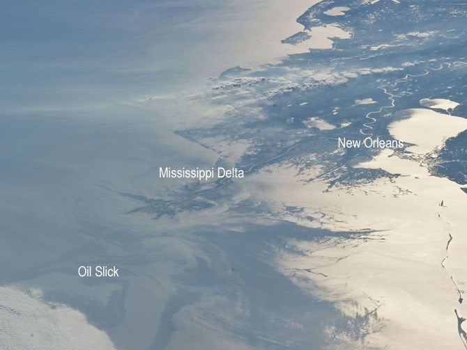
Japan Aerospace Exploration Agency (JAXA) astronaut Soichi Noguchi, Expedition 23 flight engineer, photographed the tail end of the Mississippi Delta showing the oil slick in the Gulf of Mexico on May 4, 2010. Part of the river delta and nearby Louisiana coast appear dark in the sunglint. This phenomenon is caused by sunlight reflecting off the water surface, in a mirror-like manner, directly back towards the astronaut observer onboard the International Space Station (ISS). The sunglint improves the identification of the oil spill which is creating a different water texture (and therefore a contrast) between the smooth and rougher water of the reflective ocean surface. Other features which cause a change in surface roughness that can be seen in sunglint are wind gusts, naturally occurring oils that will be gathered by and take the form of water currents or wave patterns, and less windy areas behind islands. Credit: NASA


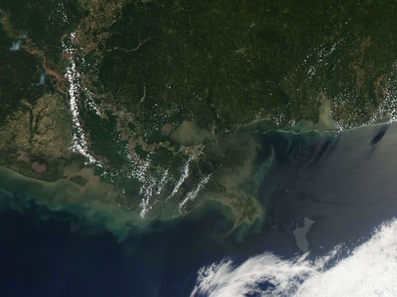
On April 29, the MODIS image on the Terra satellite captured a wide-view natural-color image of the oil slick (outlined in white) just off the Louisiana coast. The oil slick appears as dull gray interlocking comma shapes, one opaque and the other nearly transparent. Sunglint -- the mirror-like reflection of the sun off the water -- enhances the oil slick’s visibility. The northwestern tip of the oil slick almost touches the Mississippi Delta. Credit: NASA/Earth Observatory/Jesse Allen, using data provided courtesy of the University of Wisconsin’s Space Science and Engineering Center MODIS Direct Broadcast system.


NASA's Terra and Aqua satellites are helping the National Oceanic and Atmospheric Administration (NOAA) keep tabs on the extent of the recent Gulf oil spill with satellite images from time to time. NOAA is the lead agency on oil spills and uses airplane fly-overs to assess oil spill extent.

A semisubmersible drilling platform called the Deepwater Horizon located about 50 miles southeast of the Mississippi Delta experienced a fire and explosion at approximately 11 p.m. CDT on April 20. Subsequently, oil began spilling out into the Gulf of Mexico and efforts to contain the spill continue today. NASA's Terra and Aqua satellite imagery has captured the spill in between cloudy days.

NOAA used data from the Moderate Imaging Spectroradiometer or MODIS instrument from the Terra satellite on April 26, 27 and 29 to capture the extent of the oil spill, which measured 600-square-miles. The MODIS instrument flies aboard both the Terra and Aqua satellites.

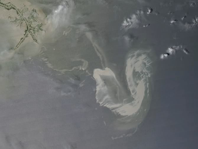
This satellite image from NASA's Terra satellite on April 27 at 12:05 CDT shows the outline and extent of the oil slick from the Deepwater Horizon drilling platform. The red dot represents the platform. The coasts of Mississippi and Alabama appear at the top of the image. Credit: NOAA/NASA
› Larger image In the satellite image from April 27 at 12:05 p.m. CDT the MODIS image showed that the oil slick was continuing to emanate from the spill location. Individual slicks lay just north of 29 degrees and zero minutes north, where they have been noted in the days before. Oil had spread further east and the edge of the slick passed 87 degrees and 30 minutes west compared to the MODIS image taken on April 26. The April 26 satellite image came from NASA's Aqua satellite.

On April 29, the MODIS image on the Terra satellite captured a natural-color image of the oil slick just off the Louisiana coast. The oil slick appeared as dull gray interlocking comma shapes, one opaque and the other nearly transparent. The northwestern tip of the oil slick almost touches the Mississippi Delta.

Deepwater Horizon had more than120 crew aboard and contained an estimated to 17,000 barrels of oil (700,000 gallons) of number two fuel oil or marine diesel fuel.

Today, April 30, NOAA declared the Deepwater Horizon incident "a Spill of National Significance (SONS)." A SONS is defined as, "a spill that, due to its severity, size, location, actual or potential impact on the public health and welfare or the environment, or the necessary response effort, is so complex that it requires extraordinary coordination of federal, state, local, and responsible party resources to contain and clean up the discharge" and allows greater federal involvement. NOAA's estimated release rate of oil spilling into the Gulf is estimated at 5,000 barrels (210,000 gallons) per day based on surface observations and reports of a newly discovered leak in the damaged piping on the sea floor.

NOAA reported on April 29 that dispersants are still being aggressively applied to the oil spill and over 100,000 gallons have been applied. NOAA's test burn late yesterday was successful and approximately 100 barrels of oil were burned in about 45 minutes. NOAA is flying planes over the area and using NASA satellite imagery from the Terra and Aqua satellites to monitor the spill.